
Were the old route markers color-coded?
In the short time (1922-1927) that NJs first highway routes were signed, there have been several changes and much confusion about the design and coloring of the original markers. We have not been able to locate any surviving samples of the old signs in the state museum or elsewhere,, nor are there any color photos. We present all of the info we were able to gather.
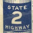
Although the state highway system was first legislated in 1926, the earliest official state map that used the numbers was 1922. In the legend of a 1922 Rand-McNally map [FIG.1], the route markers are described as being painted on telephone poles. These earliest markers used white lettering on a blue background. They are square and have "State" over the number and "Highway" under the number.
In a 1924 New York Times article, it appears that the markers are still being painted on poles but now use different colors in certain instances: "Routes 4 and 14 have a blue band running around the pole with the number 4 and 14 in the centre. Route 3 runs from Atlantic City to Camden, via the White Horse Pike, and has a yellow band with a black numeral." "The New Jersey numbering system is similar to the New England system, except that different colors are used, instead of the yellow and black adopted as uniform colors by all the New England Highway Commissioners." From the New York Times, 5-4-1924, "Road Conditions Outlined for Spring Motor Tours"
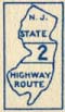
By the mid 1920s, the state was also using wooden signs mounted on wooden poles. These signs were rectangular and placed the route number inside an outline of New Jersey. A coloring scheme based on direction also seemed to be evolving. From here on in it is unclear as to whether the signs themselves were colored, the poles the signs were mounted on were colored, or both. In the legend of a 1927 Tydol Trails Map [FIG 2] both the state outline sign and a square sign that just contains the route number with stripes above and below are both shown, as well as a description of the color coding scheme. Since the markers are described as black on a colored band, the second figure is probably just a close-up of the route number on the NJ Outline sign.
According to the 1925 Official State Map: "The traveller will find poles banded along each route indicating the directions of routes as follows: Blue Banded Pole indicates that the road runs north and south. Red Banded Pole indicates that the road runs east and west. Yellow Banded Pole indicates diagonal course, south-east or north-west. Brown Banded Pole indicates diagonal course, north-east or south-west.
In a MTR newsgroup posting, Robert Droz states: "The signs prior to 1926 (actually 1928, ed.) must have been something to see: Not only did they use a sensible state outline, but they were color-coded. N-S:Blue E-W:Red NE-SW:Brown NW-SE:Yellow. " This would seem to indicate that the markers themselves were also color-coded.
We located a photo of a marker on a pole [FIG 3] from a 1926 Official State Map. (Since we took a photocopy of an already grainy black and white picture, it didn't scan well and had to be doctored up a little to compensate.) The color band on the pole is visible and there are also 2 color bands above and below the route number. You can also examine the entire sign and pole assembly [FIG 4] but it may take some time to download.
However, in correspondence from David Mudge at the NJDOT, he states: "It appears that the actual route markers were never color coded according to direction. The are two problems associated with any attempt to do so. The first is that highways often change direction along their route, shifting from a straight n-s orientation to a diagonal one, for example. Color coding the route signs would have entailed a lot of subjective decisions. Signage, on the other hand, was almost universally black lettering on white background, for visibility. It is unlikely that a colorization would have been adopted because of the reduced legibility. Finally, if the route markers themselves were colorized, there would have been no need to put colored bands on the poles. By 1927, all mention of the color band/directional scheme appears to have been dropped."
In conclusion, it appears that the colored bands were painted on the poles, and were also painted above and below the route number band. The band itself appears to be black, while the route number appears to be white. Without actually seeing one in real life, it is not possible to tell for sure. If anyone knows more about this please write to us.
![[FIG.1]](markers/1922rm.gif)
![[FIG 2]](markers/1927tt.gif)
![[FIG 3]](markers/signband.jpg)
![[FIG 4]](markers/signpost.jpg)